Blade
New member
Hello all,
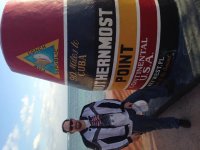
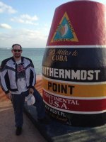
I have a plan to tour the United States four corners. Starting in Virginia going south to Florida across to southern California up the coast to Washington State then start back across to Maine down to Virginia. I would like to accomplish my trip without hitting a lot of toll roads if possible. I plan to start my journey Mid-March or early April 2016. This has been on my bucket-list for a long time. I have heard other motorcyclist talking about it, but, I have yet to meet anyone who has accomplished the ride. I am figuring that March is a good time to drive south and west because it shouldn't be too hot going across the desert going west. And by the time I am ready to head back east that the temperature should be warm enough. I'm soliciting help from people who live near any of the potential travel areas such as I-10 Texas, New Mexico, or I-5 in California or Pacific Coast Hwy, or recommend a good road to take across Washington State, Montana and could provide some insight or let me know of some fallacies I have in my travel plans.
I appreciate any information you can offer. Thanks in advance for comments/recommendations.
Blade