• There were many reasons for the change of the site software, the biggest was security. The age of the old software also meant no server updates for certain programs. There are many benefits to the new software, one of the biggest is the mobile functionality. Ill fix up some stuff in the coming days, we'll also try to get some of the old addons back or the data imported back into the site like the garage. To create a thread or to reply with a post is basically the same as it was in the prior software. The default style of the site is light colored, but i temporarily added a darker colored style, to change you can find a link at the bottom of the site.

Planning a trip...input help/comments welcome

Route 129 ( I think ) is also called " the tail of the dragon" at Deals Gap. If you like turning your Spyder it's 129 turns in 11 miles nojoke. It's out of the Asheville area. BUT---- you had better LIKE turning.;) Also best done during the week and it's well patrolled on the weekends. If you go there be sure to check out the tree of shame.

Road it on a Wing with my wife-------wish I was on a :spyder2: !!!!!!

Lew L
This information is not quite correct. The Tail of the Dragon is on Route 129. But it is 318 curves in 11 miles. It is nice to say that you did it, but not as good as many roads in the area.
Also, if you are taking the BRP to the end (in Cherokee), then this would be out of the way. It would be better to take other roads south from Cherokee. One that comes to mine would be 441 south, to Franklin and then 28 south. That is a beautiful road, and you will pass some nice waterfalls. There are many more, but it all depends on how much time you have.
If you insist on doing the Dragon, I highly insist that you do the Cherohala Skyway. They go together like peanut butter and jelly.

My mistake on the# of turns--- guess I still had 129 on my mind.;)

We were in the area for 4 days and enjoyed lots of great roads ( the ones you mentioned included) and experienced an exceptional lightning storm :yikes:.

Lew L
 
Last edited:
Route 129 ( I think ) is also called " the tail of the dragon" at Deals Gap. If you like turning your Spyder it's 129 turns in 11 miles nojoke. It's out of the Asheville area. BUT---- you had better LIKE turning.;) Also best done during the week and it's well patrolled on the weekends. If you go there be sure to check out the tree of shame.

Road it on a Wing with my wife-------wish I was on a :spyder2: !!!!!!

Lew L

Thanks, Lew. I was able to ride 'Tail of the Dragon" last fall while trailering my Spyder to FL. Stopped in Maggie Valley overnight; rode locally a piece of the Blue Ridge and up into the Smokies. Next morning, I rode over to Deal's Gap, did the Dragon and came back through Cherokee (passed up the Cherohala for lack of time) before loading up and heading on to FL. The beauty of that area is what is telling me I should just park the trailer and simply ryde the Spyder all the way down this year. Cheers.
 
I am planning trip to Maggie Valley and got the Copilot app for my iPhone. It lets you see what is around pretty easy and plan stops for gas and food. Just getting used to it. It has a motorcycle mode that plans nice back roads for a trip too. Might want to check it out I think there is a free version to look it over.

Thanks for the suggestion; I'll look into it. Cheers.
 
This information is not quite correct. The Tail of the Dragon is on Route 129. But it is 318 curves in 11 miles. It is nice to say that you did it, but not as good as many roads in the area.
Also, if you are taking the BRP to the end (in Cherokee), then this would be out of the way. It would be better to take other roads south from Cherokee. One that comes to mine would be 441 south, to Franklin and then 28 south. That is a beautiful road, and you will pass some nice waterfalls. There are many more, but it all depends on how much time you have.
If you insist on doing the Dragon, I highly insist that you do the Cherohala Skyway. They go together like peanut butter and jelly.
Appreciate the suggestions on interesting roads from Cherokee south; I'll have a look at 441 and 28. I'm very interested to learn about nice, scenic routes between Asheville and the GA/FL border. Kind of thinking of heading generally in the direction of Augusta, Valdosta, but am free to wander and very open to any and all suggestions where I can enjoy seeing the land and the people. I have all too often rushed past these sights and adventures in past while hurrying to get somewhere. Trying to learn to slow down and enjoy more while I'm still able. Thanks for your input. Cheers.
 
If you did the Tail of the Dragon and not the Cherohala Skyway, then you missed the best part. I would suggest ending your BRP run in Cherokee and keeping over to Robbinsville for the night. From there, you will be in the middle of the best roads of all. From there, you can do part of Moonshiner 28, The Dragon, Cherohala Skyway, Fontana Dam, and Fugitive Dam (from the Harrison Ford movie). You will not regret that 1 day stop over.
 
You've had a lot of good advice so here's a different twist...

I am from Ontario as well and driven to The Villages, close to your FL location, by car for the last three years. I drove highway 75 all the way from Detroit at the end of the 401. Hi 75 in Kentucky and Tennessee is very nice and even scenic in some areas. Also not too busy. So if you think you may want to do some highway at some point the 75 is way better than the 95. So you could do 401 to Detroit, back roads of Michigan and Ohio, 75 in Kentucky and Tennessee, back roads in Georgia with possibly a trip to Augusta and 75 in North FL.

Good luck

JBIM

JBIM, I have driven the Interstates, almost all of them (81, 95, 77, 79, 75), between Ontario and FL over the past 6 years, both ways, and other inter-connecting roads as well. Together with my SO, we have often done this non-stop, switching off every few hours, making the full trip, Peterborough-Leesburg, in under 24 hours. When I'm alone in my car, I'm often a 'long-haul type' driver; 12, 14, even up to 18 hours in a day, and anywhere from 700-800+ miles. On my Spyder, I try to enjoy the back roads, maybe do 300-350 miles tops in a day and actually appreciate the countryside I'm adventuring through, as well as take some time to enjoy the local people, see how they live. I've spent a working life rushing here and there, feeling 'self-important' about what it was I was supposed to be doing. Well, it was 'a living' of sorts; it paid for the groceries and toys. Now, I'm more concerned about fully enjoying the toys and the benefits of having 'paid my dues'.

I agree that 75 is a much better route then 95, by far. You might look at crossing at Buffalo, taking 90 to Cleveland, then 276 to Columbus, OH, and over to Cincinatti, to pick up 75. Saves the mess of Detroit and construction. Or, 79 from Erie, PA down to 77 and through the Carolinas is pretty decent (busier than 75), but then you have to take 26 from Columbia, SC over towards Charleston, to hook up with 95 south to FL, and that's a part of 95 I really do not enjoy driving.

So, back roads for me, along with a slower life style.

Cheers
 
Last edited:
Living Life

On my Spyder, I try to enjoy the back roads, maybe do 300-350 miles tops in a day and actually appreciate the countryside I'm adventuring through, as well as take some time to enjoy the local people, see how they live. I've spent a working life rushing here and there, feeling 'self-important' about what it was I was supposed to be doing. Well, it was 'a living' of sorts; it paid for the groceries and toys. Now, I'm more concerned about fully enjoying the toys and the benefits of having 'paid my dues'.

Great outlook! :clap: Enjoy your trip!
 
If you did the Tail of the Dragon and not the Cherohala Skyway, then you missed the best part. I would suggest ending your BRP run in Cherokee and keeping over to Robbinsville for the night. From there, you will be in the middle of the best roads of all. From there, you can do part of Moonshiner 28, The Dragon, Cherohala Skyway, Fontana Dam, and Fugitive Dam (from the Harrison Ford movie). You will not regret that 1 day stop over.

Indeed, I was aware of the beauty of the Cherohala, and perhaps passed up something I should have done. I was anxious to get to FL, so didn't spend the additional time on the Skyway last year. I did do several great portions of the routes you mention - 28, 129 (Dragon, Fontana) back through Cherokee and 19, into Maggie Valley; then drove from Waynesville on 74 and other routes in a SW direction to hook up with Interstate 75. This year, I'm looking at maybe coming off the Blue Ridge just a little west of 276 and Skinny Dip Falls, south on 215 to 64, then 64/246 west and south until I can pick up 23 near Dillard. After that, south on 23 until I can pick up 441, near Baldwin, which I can follow all the way to my FL destination.

Any comments or suggestions??? You seem to know the roads. BTW, I may divert from the Blue Ridge part way down, near Boone, to ride 'The Snake' over to Bristol, TN, then back down to the Blue Ridge, at Linville.
That sounds like a good plan that you have. If I wason 64 heading west, I would get off in Highlands and take 28 south. From Just below Highlands, you can take Warwoman Rd. This will Still take you to 23, but you will enter it in Clayton (which is further south). Warwoman rd. is a very nice rd. to compliment the leg of 28.
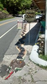
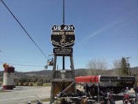
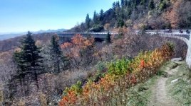
As for getting off the BRP in Boone, to do "The Snake". It is great, but that will take you back up north and west, instead of south. You could stay on the BRP to Little Switzerland and then do 226A (The Diamond Back). This is a loop, but well worth it. From there, stay off the BRP and take 221 south. Make a right on 70 west, and then another right on to hwy 80 (The Devils Whip). This will take you back to the BRP, just north of the Mt. Mitchel exit. From there you can continue south. This will keep you going south and west, instead of going north towards the Snake. If you do decide to do the Snake, get back on the BRP before linville falls so that you will not miss the Viaducts. Here are a couple of pictures taken at a few locations.
IMG_20160616_124307564_HDR.jpg
CAM00196.jpg
IMG_20141025_131503163_HDR.jpg
 
blacklightning... many, many thanks; your posts have been extremely helpful. I sincerely appreciate your knowledge of the area roads and the very welcome advice and hints on where to head. Maybe we'll meet up at some point; lunch or dinner will be on me. Cheers.

That sounds like a good plan that you have. If I wason 64 heading west, I would get off in Highlands and take 28 south. From Just below Highlands, you can take Warwoman Rd. This will Still take you to 23, but you will enter it in Clayton (which is further south). Warwoman rd. is a very nice rd. to compliment the leg of 28.
As for getting off the BRP in Boone, to do "The Snake". It is great, but that will take you back up north and west, instead of south. You could stay on the BRP to Little Switzerland and then do 226A (The Diamond Back). This is a loop, but well worth it. From there, stay off the BRP and take 221 south. Make a right on 70 west, and then another right on to hwy 80 (The Devils Whip). This will take you back to the BRP, just north of the Mt. Mitchel exit. From there you can continue south. This will keep you going south and west, instead of going north towards the Snake. If you do decide to do the Snake, get back on the BRP before linville falls so that you will not miss the Viaducts. Here are a couple of pictures taken at a few locations.View attachment 165944View attachment 165942View attachment 165943
 
blacklightning... many, many thanks; your posts have been extremely helpful. I sincerely appreciate your knowledge of the area roads and the very welcome advice and hints on where to head. Maybe we'll meet up at some point; lunch or dinner will be on me. Cheers.
Wish you could come down a bit earlier for the spyder adventures in Maggie Valley. We will be there 10/10-14. Either way, you should have quite an adventure. God Speed.
Been going to the NC/Tenn mountains and surrounding areas every year (sometimes 2-3 times) for the past 10. My early retirement plan would to be to buy a cabin up there and run daily tours, rides, and give ride reports. Hey, it would be a dream job, but I guy can dream.
 
Last edited:
Hey bushrat, I'm 77 and new to riding and just picked up an F3L a few weeks ago. Sounds like a fun trip your planning. If you would like a companion on your trip I would happy to join you. I'm in Vineland NJ. Of course I'd have to get the proper cold weather gear. Let me know what you think.

Joe
 
Hey bushrat, I'm 77 and new to riding and just picked up an F3L a few weeks ago. Sounds like a fun trip your planning. If you would like a companion on your trip I would happy to join you. I'm in Vineland NJ. Of course I'd have to get the proper cold weather gear. Let me know what you think.

Joe

Hi Joe:
It would be great to have some company on this adventure. I am sending you a PM, and we can discuss details further. Thanks for this.
Roger
 
Interesting, if you google BRP first thing that comes up is "Bombardier Recreational Products" :yes:
 
Back
Top