-
There were many reasons for the change of the site software, the biggest was security. The age of the old software also meant no server updates for certain programs. There are many benefits to the new software, one of the biggest is the mobile functionality. Ill fix up some stuff in the coming days, we'll also try to get some of the old addons back or the data imported back into the site like the garage. To create a thread or to reply with a post is basically the same as it was in the prior software. The default style of the site is light colored, but i temporarily added a darker colored style, to change you can find a link at the bottom of the site.
You are using an out of date browser. It may not display this or other websites correctly.
You should upgrade or use an alternative browser.
You should upgrade or use an alternative browser.
North to Alaska Blog
- Thread starter SpyderAnn01
- Start date
SpyderAnn01
Active member
NautiBrit
Member
We made it to Beaver Creek, YT, safely on Canadian soil. Caught some showers and rode 420 miles. Next stop is Teslin, YT, another almost 400 mile day. I'm beginning to doubt that getting the heat update to my 2013 was such a good idea before this trip, as it's been pretty cold fespecially in the mornings. The benefit is that my gas mileage is up from 2-4 mpg with or without the trailer.
We shivered a bit again today, stopped for lunch in a gas station/restaurant and asked for hot soup. We were told that because of the heat wave, it was barely 70, that they didn't make soup today. Different strokes.............
We shivered a bit again today, stopped for lunch in a gas station/restaurant and asked for hot soup. We were told that because of the heat wave, it was barely 70, that they didn't make soup today. Different strokes.............
cptjam
Registered User
Tok
Healy to Tok today. Light showers, 60 degrees. Hard bump caused a code to be thrown. Cleared it and drove on. Stopped to help a soldier broken down at a rest area. Nice young man. Fixed it and used our cool lithium jump start battery. Add that to the list of must have traveling tools! Idk why we have clothes! All we wear is rain gear! Bring at least 4 pairs of gloves: regular, cold dry, cold wet, warm wet. I also have a pair of over gloves, for the cool wet. Hands have to be right! Feet, too! Dry and comfy all day! Muktuk tomorrow!
Healy to Tok today. Light showers, 60 degrees. Hard bump caused a code to be thrown. Cleared it and drove on. Stopped to help a soldier broken down at a rest area. Nice young man. Fixed it and used our cool lithium jump start battery. Add that to the list of must have traveling tools! Idk why we have clothes! All we wear is rain gear! Bring at least 4 pairs of gloves: regular, cold dry, cold wet, warm wet. I also have a pair of over gloves, for the cool wet. Hands have to be right! Feet, too! Dry and comfy all day! Muktuk tomorrow!


missouriboy
Active member
Keep a close eye on your GPS there... Delta Junction was where my GPS quit, back in 2008. :roflblack:I heard Murphybrown start her Spyder at 3:00 am and I could hear her for at least a mile. I wished them safe travels from my bed. We are enjoying our ride to Tok. Having lunch at the Buffalo Drive In in beautiful downtown Delta Junction.
SpyderAnn01
Active member
The highway was quite a bit smoother going south than it was when we headed north. We are through the worst and the rest of the trip should be smooth sailing. We are heading to MukTuk to sleep with the dogs tonight. Then tomorrow we split from Tom and Robin and start to hightail it home.
PrairieSpyder
New member
Sunday I was able to take my time leaving Healy since I didn't have anything in particular planned until Monday. I enjoyed my ryde to Fairbanks and located the place where I'd get the plane on Monday and then my hotel. Today I got a hotel shuttle to the airport and got on a Piper Navajo 9-passenger twin with 5 Swedes and went to Barrow, Alaska.
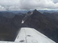
On the flight up, we stopped at Cold Foot, north of the Arctic Circle, for fuel and a "comfort" break. Our pilot, Todd, pointed out many things en route and gave us some history of some of the places we flew over. This is fire season and they generally don't try to put them out unless they threaten populated areas or the pipeline. After Cold Foot, we overflew the Gates of the Arctic National Park. The name is from 2 mountains in a river valley that are like gateposts in the mountain pass. We flew low right between them and it was beautiful. They are part of the Brooks range.
We landed in Barrow in fog and we felt drizzle in the air when we got out of the plane. The wind made everything feel colder. But on the tour the drizzle diminished and it wasn't too bad. I took extra layers to put on but didn't need them.
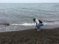
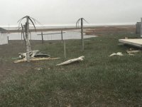
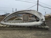
Barrow is really interesting to tour the little town and learn about how people live there year-round. The town is only 55% indigenous people. Apparently there are a lot of scientists there. We went out on the peninsula about a mile from Point Barrow, the northern-most land in the Americas. We couldn't go all the way out because it was just fine gravel and the van wasn't equipped for that. I had planned on taking off a shoe and sock and at least dipping a toe into the Arctic Ocean, but chickened out and dipped my hand in instead. We saw lots of whale skulls, signs shot up (apparently the Alaska state pass-time), houses with lots of junk around them. They save and reuse everything, so it pays to have a pile of stuff in the yard so you don't have to buy when it's so expensive. The guide said gasoline is $7/gal.
I asked the guide how they get the cars there. He said there are 2 ways: (1) bring them in by barge from Anchorage or Seattle at a cost of about $5000, or (2) drive them there. But there are no roads to Barrow, so in the winter they come up the Dalton Highway to Deadhorse and then drive an ice-road along the coast to Barrow. This method runs about $1200.
Someone asked about funeral practices, assuming they used cremation since the ground is frozen so much of the time. But that's not the case. They can bury even in the winter, using the same machines they use to drive pilings into the permafrost. And the bodies buried int the permafrost never decay; so they will always be int the same state as when they are buried. He showed us "Mound 44," a mound of earth right above the beach. It's named that because they needed some way to identify an address for a possible crime scene when human legs were found to be protruding from the mound. It got roped off with crime-scene tape and all until they eventually got some archeologists there to excavate. It turned out to be a mother and children from about 2000 years ago. At that time the people built houses from whale bones and then covered them with sod. Apparently the house caved in on the people and they were trapped there and died. That is what formed the mound. There's an area full of collapsed mounds and it's believed there are bodies in them. It was the custom to leave the deceased in their place with their stuff and not disturb it. So all those collapsed mounds contain buried people from long ago. We walked among them and could see some of the exposed whale bones that formed the sod houses structures.
I asked about their diet, and do they grow vegetables in greenhouses. No, the indigenous diet is about 95% meat, but, traditionally, it's not cooked and so they get all the nutrition from the animal, which is often diminished in food preparation. They eat polar bear, whale, walrus, seals, fish, caribou, birds.
There is a central power plant for the town, burning natural gas, which is abundant on the north slope. At each house is a big round pipe sticking out of the ground and then a big black pipe goes from there under and into the house. This delivers heat and electric. So houses don't need furnaces, but they have water heaters.
I took some pictures but will put them up later. I wanted to write about this while it was still fresh in my mind. I'm sure I've forgotten something, but will add to it later if I can come up with more.
On the flight up, we stopped at Cold Foot, north of the Arctic Circle, for fuel and a "comfort" break. Our pilot, Todd, pointed out many things en route and gave us some history of some of the places we flew over. This is fire season and they generally don't try to put them out unless they threaten populated areas or the pipeline. After Cold Foot, we overflew the Gates of the Arctic National Park. The name is from 2 mountains in a river valley that are like gateposts in the mountain pass. We flew low right between them and it was beautiful. They are part of the Brooks range.
We landed in Barrow in fog and we felt drizzle in the air when we got out of the plane. The wind made everything feel colder. But on the tour the drizzle diminished and it wasn't too bad. I took extra layers to put on but didn't need them.
Barrow is really interesting to tour the little town and learn about how people live there year-round. The town is only 55% indigenous people. Apparently there are a lot of scientists there. We went out on the peninsula about a mile from Point Barrow, the northern-most land in the Americas. We couldn't go all the way out because it was just fine gravel and the van wasn't equipped for that. I had planned on taking off a shoe and sock and at least dipping a toe into the Arctic Ocean, but chickened out and dipped my hand in instead. We saw lots of whale skulls, signs shot up (apparently the Alaska state pass-time), houses with lots of junk around them. They save and reuse everything, so it pays to have a pile of stuff in the yard so you don't have to buy when it's so expensive. The guide said gasoline is $7/gal.
I asked the guide how they get the cars there. He said there are 2 ways: (1) bring them in by barge from Anchorage or Seattle at a cost of about $5000, or (2) drive them there. But there are no roads to Barrow, so in the winter they come up the Dalton Highway to Deadhorse and then drive an ice-road along the coast to Barrow. This method runs about $1200.
Someone asked about funeral practices, assuming they used cremation since the ground is frozen so much of the time. But that's not the case. They can bury even in the winter, using the same machines they use to drive pilings into the permafrost. And the bodies buried int the permafrost never decay; so they will always be int the same state as when they are buried. He showed us "Mound 44," a mound of earth right above the beach. It's named that because they needed some way to identify an address for a possible crime scene when human legs were found to be protruding from the mound. It got roped off with crime-scene tape and all until they eventually got some archeologists there to excavate. It turned out to be a mother and children from about 2000 years ago. At that time the people built houses from whale bones and then covered them with sod. Apparently the house caved in on the people and they were trapped there and died. That is what formed the mound. There's an area full of collapsed mounds and it's believed there are bodies in them. It was the custom to leave the deceased in their place with their stuff and not disturb it. So all those collapsed mounds contain buried people from long ago. We walked among them and could see some of the exposed whale bones that formed the sod houses structures.
I asked about their diet, and do they grow vegetables in greenhouses. No, the indigenous diet is about 95% meat, but, traditionally, it's not cooked and so they get all the nutrition from the animal, which is often diminished in food preparation. They eat polar bear, whale, walrus, seals, fish, caribou, birds.
There is a central power plant for the town, burning natural gas, which is abundant on the north slope. At each house is a big round pipe sticking out of the ground and then a big black pipe goes from there under and into the house. This delivers heat and electric. So houses don't need furnaces, but they have water heaters.
I took some pictures but will put them up later. I wanted to write about this while it was still fresh in my mind. I'm sure I've forgotten something, but will add to it later if I can come up with more.
Bob Denman
New member
Thanks, Patti!
I find all of this to be fascinating! Please keep telling the stories, and posting the GREAT pictures! :clap:
I find all of this to be fascinating! Please keep telling the stories, and posting the GREAT pictures! :clap:
vided
New member
Thanks, Patti!
I find all of this to be fascinating! Please keep telling the stories, and posting the GREAT pictures! :clap:
:agree::agree::agree::agree::agree: exactly what he said :thumbup::thumbup::thumbup::thumbup::thumbup::thumbup:
NautiBrit
Member
Muncho Lake
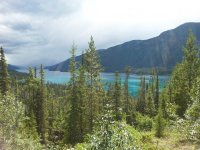
We're spending tonight in Muncho Lake, BC. The water is almost fluorescent, much like the lake we saw on the way down to Skagway. Once out of the Yukon, the roads improved with very few gravel sections or sections under repair.
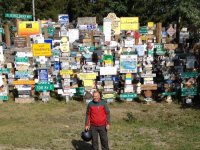
We stopped at the signpost forest in Watson Lake, there are thousands of signs covering about 2 acres.
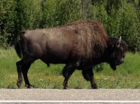
We also shared the road with some buffalo, this one was big enough to require his own license plate.
We're spending tonight in Muncho Lake, BC. The water is almost fluorescent, much like the lake we saw on the way down to Skagway. Once out of the Yukon, the roads improved with very few gravel sections or sections under repair.
We stopped at the signpost forest in Watson Lake, there are thousands of signs covering about 2 acres.
We also shared the road with some buffalo, this one was big enough to require his own license plate.
Attachments
lil rabbit
New member
The highway was quite a bit smoother going south than it was when we headed north. We are through the worst and the rest of the trip should be smooth sailing. We are heading to MukTuk to sleep with the dogs tonight. Then tomorrow we split from Tom and Robin and start to hightail it home.
Have a safe travel home and see you guys at SITR.......
SpyderAnn01
Active member
It was just Joe and me today and we made good time. We ride from north of Whitehorse, YT to Iskut, BC s distance of approx 475 miles. The Alaska Highway portion was nice and smooth but the Stewart-Cassair Rd is a two lane with no markings and no shoulders. It gets tiring after a while.
We ran into three guys (a Honda trike, Honda MC and an HD) today at every stop. These are the same three that we saw last week between Destruction Bay and Beaver. I'm sure we will see them again tomorrow. They went to pretty much the same places as our group did but they went to Fsirbanks first and then to Anchorage.
Tomorrow we go 570 miles to Prince George BC which is pretty much returning to civilization. Bye bye gravel and mud and hello paved parking lots. My spyder is so dirty you wouldn't know what color it is if i didn't tell you.
cptjam
Registered User
Tatoga
Back to the lodge at Tatoga! Rode thru rain, wind, cold and gravel roads. Skipped Teslin, made good time. Bikes running flawlessly! Over 9000kilometers so far. I am in love with heated seats and grips! Needed them today. Couple times into the mid 40's. Great trip! Joe
Back to the lodge at Tatoga! Rode thru rain, wind, cold and gravel roads. Skipped Teslin, made good time. Bikes running flawlessly! Over 9000kilometers so far. I am in love with heated seats and grips! Needed them today. Couple times into the mid 40's. Great trip! Joe
PrairieSpyder
New member
The highway was quite a bit smoother going south than it was when we headed north. We are through the worst and the rest of the trip should be smooth sailing. We are heading to MukTuk to sleep with the dogs tonight. Then tomorrow we split from Tom and Robin and start to hightail it home.
Why do you suppose that is? Did they improve it since we went north a week ago? Or are you more used to it?
It was just Joe and me today and we made good time. We ride from north of Whitehorse, YT to Iskut, BC s distance of approx 475 miles. The Alaska Highway portion was nice and smooth but the Stewart-Cassair Rd is a two lane with no markings and no shoulders. It gets tiring after a while. We ran into three guys (a Honda trike, Honda MC and an HD) today at every stop. These are the same three that we saw last week between Destruction Bay and Beaver. I'm sure we will see them again tomorrow. They went to pretty much the same places as our group did but they went to Fsirbanks first and then to Anchorage. Tomorrow we go 570 miles to Prince George BC which is pretty much returning to civilization. Bye bye gravel and mud and hello paved parking lots. My spyder is so dirty you wouldn't know what color it is if i didn't tell you.
Don't forget to return the key to room #3, please!
PrairieSpyder
New member
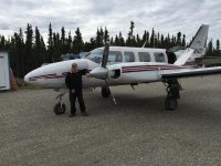
Pilot Todd with the Piper Navajo

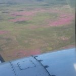
Big field of fireweed. It's the first thing to bloom after a fire.

The Arctic Circle latitude is 66 deg 33 min. I couldn't get the pic fast enough.

Flying thru the Gates of the Arctic.

Big field of fireweed. It's the first thing to bloom after a fire.
The Arctic Circle latitude is 66 deg 33 min. I couldn't get the pic fast enough.
Flying thru the Gates of the Arctic.
Attachments
PrairieSpyder
New member
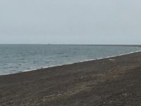
That's Point Barrow way off in the distance.

The Arctic Ocean is really cold!

Palm trees in Barrow! Made from drift wood & whale baleen. Baleen is hairy whale teeth.

Whale scull

The Arctic Ocean is really cold!
Palm trees in Barrow! Made from drift wood & whale baleen. Baleen is hairy whale teeth.
Whale scull
Attachments
Similar threads
- Replies
- 22
- Views
- 2K
- Replies
- 29
- Views
- 3K
- Replies
- 25
- Views
- 1K
- Replies
- 10
- Views
- 1K
- Replies
- 10
- Views
- 442