• There were many reasons for the change of the site software, the biggest was security. The age of the old software also meant no server updates for certain programs. There are many benefits to the new software, one of the biggest is the mobile functionality. Ill fix up some stuff in the coming days, we'll also try to get some of the old addons back or the data imported back into the site like the garage. To create a thread or to reply with a post is basically the same as it was in the prior software. The default style of the site is light colored, but i temporarily added a darker colored style, to change you can find a link at the bottom of the site.

Spyderfest Routes - How are you getting there?

kinggeek

New member
Thought it might be intresting to see how everyone is getting to Spyderfest. Google earth is a pretty cool way to visualize this.

I am leaving Tuesday evening and will find a place to stay on the way Tuesday night. I will arrive in Cuba, MO Wednesday morning.

Below is my route:
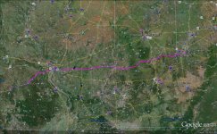
Spyderfest 2012 Route.jpg

How are you getting there from where you are?
 
We are taking MO61 south then getting on MO19 just south of New London. MO19 is a very nice 2 lane road and it gets very scenic as you get close to Hermann. :thumbup:
 
untitled.jpg

My route is I-8 to Gila Bend, AZ, back hwys up to the 40, taking that to Oklahoma City and then hitting the 44.
 
Last edited:
It is 4 left turns for me and I'm there. US93/95 turn left at I40 hang a left to I44 and a left in Cuba! I feel like I could travel I40 with my eyes closed but I'll try my hardest to stay awake.
 
My circle tour...

Leaving Harrisburg, down I81 and accross to Nashville (to visit my daughter). Then west to St,. Louis and on to Cuba. Going back stopping in Columbus, OH to visit family and back to Harrisburg. I'm leaving 4/21 and won't get back home until 5/2.


BTW, went out for a ride during lunch at work, 75 degrees, no humidity, blinding sun and ZZ Top came on the radio... thought I was in a Spyder commercial!!!!!
 
Thought it might be intresting to see how everyone is getting to Spyderfest. Google earth is a pretty cool way to visualize this.

I am leaving Tuesday evening and will find a place to stay on the way Tuesday night. I will arrive in Cuba, MO Wednesday morning.

Below is my route:

View attachment 44163

How are you getting there from where you are?

Can you tell me how to copy your map on google to put in SL
 
driving route and timing

Leaving Harrisburg, down I81 and accross to Nashville (to visit my daughter). Then west to St,. Louis and on to Cuba. Going back stopping in Columbus, OH to visit family and back to Harrisburg. I'm leaving 4/21 and won't get back home until 5/2.


BTW, went out for a ride during lunch at work, 75 degrees, no humidity, blinding sun and ZZ Top came on the radio... thought I was in a Spyder commercial!!!!!


We will travel I85 to I40 to I77 to I 64 To I44...just about 1,000 miles. Leaving Sunday (stop and see kids and new grandbaby Lexie) then three nights of stops and arrive in Cuba mid-morning on Wednesday!
 
I'm taking back roads almost the whole way....will be on I-45 to Beltway to I-10 for about 40 miles ...to get out of Houston...then I start back roads...13 of them....unless hg changes my mind....see y'all @ Spyderfest:2excited::yes::2excited::yes::2excited::yes::yes::yes:
 
View attachment 44169

My route is I-8 to Gila Bend, AZ, back hwys up to the 40, taking that to Oklahoma City and then hitting the 44.

BTW, I'm doing a Saddlesore 1000 right out the gate, from San Diego to Amarillo, TX. Then I will be pacing myself with about 400 the last 2 nights before arriving in Cuba (Rolla) on the 24th.
 
Garmin Basecamp

Can you tell me how to copy your map on google to put in SL

I have a Garmin GPS and maps. Garmin has a free app called Basecamp that exports routes directly to Google Earth. It is really cool becuse you can actually zoom in and do a flyby on your entire route complete with selectable points of interest.
 
Right on DD 2 miles, right on to old Springfield for 3miles, left on to Daniels Rd 1/2 mile I'm there, again and again and again and again...... I think there's a pattern:shocked:
 
Curtice, OH to Cuba, MO

The most direct route would be this: http://maps.google.com/maps?saddr=C...0e87bhzENIVh52ZHGwg&oq=Curtice&mra=ls&t=m&z=7
Approx. 584 Miles

But I will be avoiding the interstates as much as possible SO:

Depart AM Monday, 23 APR
US65/US424/US24, bypass Fort Wayne, IN via I469
South on US27 and other state routes to US50 to Bedford, IN or there-abouts for the night.

Depart AM Tuesday, 24 APR
US50 West, Then bypass St. Louis (don't know the best way around except I255)
Continue on US50 to I44 to Comfort Inn, Sullivan, MO and Cuba, MO.

Approx. 670 miles.

The RTS & trailer are clean and waiting. I'll pack everything tomorrow.
See down the road,
Keep the shiny side up!
 
Last edited:
Routing

I'll be heading to Cincinnati via I-71 on Sunday. Staying with my daughter and departing for Cuba via I-71,
I-64 and I-44 early Monday morning. I'll be taking the southern route thru Louisville to St. Louis because it's more scenic
than the Indianapolis route. Then on to Cuba. Milage is about 451mi. and should take me about 8-9 hours
barring any Imperial Entanglements.
 
Back
Top