• There were many reasons for the change of the site software, the biggest was security. The age of the old software also meant no server updates for certain programs. There are many benefits to the new software, one of the biggest is the mobile functionality. Ill fix up some stuff in the coming days, we'll also try to get some of the old addons back or the data imported back into the site like the garage. To create a thread or to reply with a post is basically the same as it was in the prior software. The default style of the site is light colored, but i temporarily added a darker colored style, to change you can find a link at the bottom of the site.

Need Help identifying a particular road or route in Arizona?

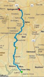
Need help locating a particular road in eastern Arizona or possibly in New Mexico. Several years ago, I flew into Phoenix and drove to Show Low, AZ for a couple days work. When it was time to return to the airport, I had some extra time to kill so I picked a route that I believe went east out of Show Low then turned south. The route was stunning, and I vowed to return someday on a bike. Someday is now and doing my trip research I was sure the road I was seeking was Hwy 191 (the Devil’s Highway)...

Today I rode Hwy 191 from Eadgar to Three Way and although it was a great route it isn’t the route I remembered. The route I’m seeking, you followed along a canyon for miles and the canyon had lots of hoodoos in it. Anyone have an idea what road it might be, could it be Hwy 180 just over the AZ line in NM?
 
Last edited by a moderator:
I think you're looking for Hwy 60 goes thru Salt River Canyon to Globe. The canyon is awesome. I actually went to visit my Grandparents from Ohio to Mesa, AZ in 1978, went thru Petrified Forest, then into Mesa via the route I'm telling you. Look on a map and let me know if this seems like the one you're looking for!!
 
Last edited by a moderator:
Thanks for the quick response, but highway 60 isn’t it as I took it yesterday and took it from Phoenix to Show Low… there is an awesome section of canyon but I don’t think that’s the road/canyon I’m looking for. I pretty sure it’s further east, but then again it was several years ago and I’m older now :roflblack:
 
Probably Highway 191

This is a very scenic twisty road. Alpine to Three Way!

Highway 191_1.jpg
 
Last edited by a moderator:
If you took a route from Eagar to Three way it had to be US 191. That is one of the most amazing routes I've ever taken. The part from Alpine to Three Way is 90 miles and ~534 curves though the mountains and a copper mine pit that covers 19,000 acres in three pits.
 

Attachments

  • Eagar23way.jpg
    Eagar23way.jpg
    47.1 KB · Views: 16
Peter, I think the route might have been 60 east out of Show Low, then south on 191 to Alpine and there picking up US 180 east into NM then south towards Silver City. Have ridden that many times and it is an excellent motorcycle tour.
 
I think you're looking for Hwy 60 goes thru Salt River Canyon to Globe. The canyon is awesome. I actually went to visit my Grandparents from Ohio to Mesa, AZ in 1978, went thru Petrified Forest, then into Mesa via the route I'm telling you. Look on a map and let me know if this seems like the one you're looking for!!

That’s a possibility. I took Hwy 60 two days ago from Phoenix to Show Low and although it is a terrific route and it does have a canyon running next to it, it didn’t seem familiar. However, this time I took 60 going south to north and the “mystery route” I drove from north to south and with many years in between traveling different directions could be why it did look familiar this time.

Probably Highway 191

This is a very scenic twisty road. Alpine to Three Way!

No doubt that is a great route, I enjoyed the heck out of it. I might even be tempted to put it in my top 10 all-time best route’s I’ve ever ridden. But it is not the route I’m trying to re-find.

* There’s an idea for a new thread - Top Ten Routes in the US!

If you took a route from Eagar to Three way it had to be US 191. That is one of the most amazing routes I've ever taken. The part from Alpine to Three Way is 90 miles and ~534 curves though the mountains and a copper mine pit that covers 19,000 acres in three pits.

Absolutely agree with you and it is quite an upper body workout too; but it isn’t my mystery route, LOL!

You only have 3 choices that it could be. 191, 60, or 87 out of Payson

I’ve ridden all three of those routes this trip and it’s possible Hwy 60 is it, but I’m not completely convinced yet.

Peter, I think the route might have been 60 east out of Show Low, then south on 191 to Alpine and there picking up US 180 east into NM then south towards Silver City. Have ridden that many times and it is an excellent motorcycle tour.

I looked on the map and this route has potential mystery route and Hwy 78 coming off of 180 just north of Buckhorn, NM needs to be investigated too. I’m going to try to get to them before I leave the area, I’ll report my findings.

I took the Mogollon Rim road into Show Low 30yrs ago. It was gravel and I was in a car.

Unfortunately, my mapping app shows large sections of this route is still unpaved and the route I’m thinking of was all paved. I would like to ride that route sometime, but that's not going to happen on the Spyder.
 
Last edited by a moderator:
Back
Top