Spyder Tony
New member
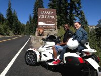
My girlfriend suggested last Saturday that we go to Lassen National Park on the Spyder. This will mark the longest single road trip I have been on solo (no group ride) since purchasing the Spyder. We left the house @ 9 sharp and didn't return until 8:15 that evening. It was a great learning experience as I found out first-hand the following:
1: When travelling the "back roads" plan out your fuel stops
2: Be aware that there are stretches where gas may not be found for 60 miles (or more)
3: Riding 2-up uphill through twisties really eats up the gas
Among the adventures was almost running out of gas, as I chose to forego the last gas stop due to having 1/2 tank already. What I didn't account for was passing through several small towns with no gas station (See #2) and we were travelling 2-up through twisties mostly uphill...which was really eating up the gas I had (See #3). Had to backtrack 40 miles as this was the nearest gas. There is no feeling in the world like seeing your gas light come on with NO BARS left on the gas meter & the road sign says you still have 29 miles until the next town. As a result of my near scare, I am looking into carrying a small gas can (a gallon or 2) in one of the saddlebags as a precaution. Otherwise, the trip was a blast, and I had a chance to get some real great pix of the Spyder along the way. Will definitely do this trip again. Here is the route I took:
Sacramento HWY 5 North to Red Bluff (130 miles). From Red Bluff take route 36 east to Lassen Volcanic National Park, turn north on route 89, that section of the Hwy is open only from late spring to Fall due to snow, during summer it is a real breathtaking sight, there is a charge to go through Lassen Volcanic National Park, but it's worth it, I've done that ride more than three different times, Then turn west on route 44, that will take you to Redding.
Scenery
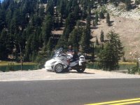
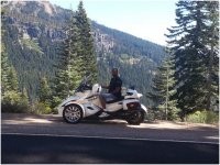
Since you leave Red Bluff, on Route 36, the view is just plain special, to start there is a section of the road that goes straight for about 8 miles, but don't worry, that is just to give you the chance to admire the landscape to both sides of the road, with endless miles of lava rock and reddish clay combine to form a picture that you'll never forget, then the Hwy treats you with miles of twists and corners to enjoy, along with the view of the side hills right by the road, so close that you can feel yourself as part of them. And when you turn on Route 89, you'll have a road that feels like is eaten by the pine trees, that gives you the gift of a cool breeze, to leave behind the warm weather of the valley, as you climb the mountain road you are going to experience the most amazing view, to your right there are all the mountains that were so impressive, they will be shrunken by the one you are climbing and you'll be standing way above them, and they will look like a carpet at your feet, to your left, there is the real impressive Mt. Lassen, the giant that invites you to come back, with the simple view that is offering to you. Then when you get to the summit of the road at 8,511 feet, the road starts to get lost in the pine trees again but this time it offers a different landscape for you to conquer, but the opposite happens, because is all this what takes over your senses. (126 miles)
Right where 89 meets 44 there is Manzanita lake, and a museum, and to end your ride Route 44 is going to open itself to you with a relaxing, but still breathtaking 30 mile ride to Redding.
1: When travelling the "back roads" plan out your fuel stops
2: Be aware that there are stretches where gas may not be found for 60 miles (or more)
3: Riding 2-up uphill through twisties really eats up the gas
Among the adventures was almost running out of gas, as I chose to forego the last gas stop due to having 1/2 tank already. What I didn't account for was passing through several small towns with no gas station (See #2) and we were travelling 2-up through twisties mostly uphill...which was really eating up the gas I had (See #3). Had to backtrack 40 miles as this was the nearest gas. There is no feeling in the world like seeing your gas light come on with NO BARS left on the gas meter & the road sign says you still have 29 miles until the next town. As a result of my near scare, I am looking into carrying a small gas can (a gallon or 2) in one of the saddlebags as a precaution. Otherwise, the trip was a blast, and I had a chance to get some real great pix of the Spyder along the way. Will definitely do this trip again. Here is the route I took:
Sacramento HWY 5 North to Red Bluff (130 miles). From Red Bluff take route 36 east to Lassen Volcanic National Park, turn north on route 89, that section of the Hwy is open only from late spring to Fall due to snow, during summer it is a real breathtaking sight, there is a charge to go through Lassen Volcanic National Park, but it's worth it, I've done that ride more than three different times, Then turn west on route 44, that will take you to Redding.
Scenery
Since you leave Red Bluff, on Route 36, the view is just plain special, to start there is a section of the road that goes straight for about 8 miles, but don't worry, that is just to give you the chance to admire the landscape to both sides of the road, with endless miles of lava rock and reddish clay combine to form a picture that you'll never forget, then the Hwy treats you with miles of twists and corners to enjoy, along with the view of the side hills right by the road, so close that you can feel yourself as part of them. And when you turn on Route 89, you'll have a road that feels like is eaten by the pine trees, that gives you the gift of a cool breeze, to leave behind the warm weather of the valley, as you climb the mountain road you are going to experience the most amazing view, to your right there are all the mountains that were so impressive, they will be shrunken by the one you are climbing and you'll be standing way above them, and they will look like a carpet at your feet, to your left, there is the real impressive Mt. Lassen, the giant that invites you to come back, with the simple view that is offering to you. Then when you get to the summit of the road at 8,511 feet, the road starts to get lost in the pine trees again but this time it offers a different landscape for you to conquer, but the opposite happens, because is all this what takes over your senses. (126 miles)
Right where 89 meets 44 there is Manzanita lake, and a museum, and to end your ride Route 44 is going to open itself to you with a relaxing, but still breathtaking 30 mile ride to Redding.


")