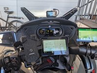
I'll chip in here, if I may. Newbie member - I don't even get my Spyder until tomorrow morning, but I do know quite a lot about the Zumos, and currently have the XT1 and XT2 (The XT1 is actually called the XT, but I tend to add the '1' so that people know it isn't a Typo.)
The XT1 and XT2 both have issues with GPX route files. The XT2 particularly so. But over at zumouserforums.co.uk, we have solutions for most of these. Personally, I consider the Zumo 590 to be the most predictable in terms of what it will do - for example, when you deviate from the plotted route. I do not use the 590 or 595 much these days - except to answer queries. It is the XT2 that was the one fitted to my motorcycle - until I gave that to my brother in order to clear space for the Spyder. The XT2 will be mounted (when I find out how) to my new ride.
The XT2 works with an app called Tread on your phone which synchs your routes, tracks, and waypoints between cloud storage - at your account at Explore.garmin.com. The XT1 does something similar via an app on your phone called 'Drive'. It seems to be this particular feature that causes problems with the XT2: It nearly always changes the name and the location of any point that you have plotted to form your route - to the extent that if you have placed 'Shaping Points' on roads specifically because you want to ride that road, the XT2 will very often move them onto a nearby faster road. Which makes a complete mess of your carefully planned route. The same happens with 'Via Points'.
Another issue with the XT1 and XT2 is that if you use gpx files for your routes, the Zumo has to import them and build a valid route from what it finds. In doing so, the XT2 in particular applies a sort of fuzzy logic to your points and 'improves' them to locations that it alread knows about. This is when it seems to move and rename the locations. It then builds a filename.trip which is stored in a hidden System folder, with all of these new route points. But it also flags the route as being 'imported', rather than having been created and saved by the Zumo's own Route Planner App. That is significant because if you have to deviate from the route, and the route is recalculated - particularly if you have had to 'skip' a route point that you can no longer visit - the XT1 and XT2 seem to recalculate the route using a different algorithm form the one that it uses if the route was 'saved' - ie created on the XT1/XT2 itself. What it does is head for the nearest point on the route 'ahead' rather than calculating a route to the next plotted route point (via or shaping). That is significant, because if it decides that the closest point is behind you, it will want to send you back. You ignore it, and the route it has just calculated starts at where it last asked you to go back. So it gets stuck in a never ending loop. If U turns are allowed, this is very obvious. If they are not, it still does the same thing but it has to use other techniques to get you to go back.
I discovered this behaviour first on the XT1 and came up with the term RUT to describe it. Like being stuck in a rut from which it can never escape. But 'Repeated U Turns' is often one of the symptoms.
However, these problems are all manageable.
On the XT2 - RUT behaviour can be prevented simply by using the copy facility to make a copy of the route. Use the copy instead of the original.
The other issues can also be solved by by-passing the XT1 and XT2's importing process to convert what it finds in a gpx file to the filename.trip entry in the hidden .System folder. To that end, FrankB on the zumouser forums has developed a piece of software for the PC which creates the trip file from your gpx file. The points keep their names, they keep their locations precisely where you plotted them, and the route loads and calculates without any issue. It also cures the RUT issue without having to make a copy of the route.
Like most mapping software, it relies on the accuracy of the main route points - the via and shaping points. The Zumo still has to calculate these - rather like using MyRouteApp's gpx v1.1. But you can send the track as well as the route as a reference.
Some people like to use tracks and let the XT1/XT2 convert them to trips / routes. That works well for some people - but these 'Track2Trips' can also display RUT behaviour.
So I use:
- Basecamp to plot the routes. In my opinion, it is still the best route planning software, using the same maps as the Zumo.
- The Tread App so that I have access to up ahead places, weather, traffic etc.
- I do not allow the Tread App to synchronise with the XT1/XT2 or to store the data.
- Trip Manager to send the GPX file to the XT1/XT2.
- Tracks created from the route which I display at the same time as the route.
- My Theme file is tweaked slightly to make the track slightly wider than the route, so I can always see it.
Downside. I have to transfer the route using the USB cable - but for me that is not an issue.
MRA is a good alternative to Basecamp - especially since it has a web based routing facility. But use v 1.1 for GPX export. And beware that MRA's 'Waypoints' are not the same as Garmin's Waypoints.
All the above makes the XT1 and XT2 a real friend - something that you can rely on. Or ask on here, mention me with the @ prefix - eg
@JohnRtl and I will be alerted.
(When talking XT1/XT2 the terms 'Route' and 'Trip' are interchangeable. The XT2 always calls them 'Route'. The XT1 calls them 'Trips'. They are referring to exactly the same thing).
Now - what I really want to know is where I can tap into an 'On with ignition' line to trigger a relay supplying accessory power direct from the battery, to fit my XT2 and camera? But that is another question. I'll go hunting first - someone is likely to have mentioned it.


